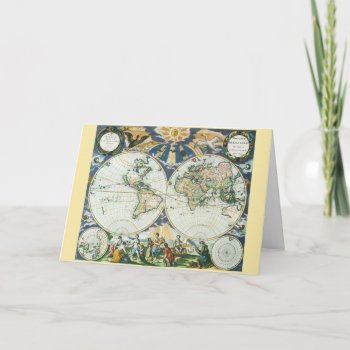
Vintage illustration antique world map featuring birds flying towards a shining sun casting rays over the hemispheres and continents. Below the chart is a set of allegorical figures representing the four seasons, summer, autumn, spring and winter. Orbis terrarum nova et accuratissima tabula. Artist: Pieter Goos, 1666.
Continue reading
Tag Archives: mercator
Antique Old World Map of Africa, c. 1635 Mouse Pads
Vintage illustration antique world map featuring the continent of Africa and the island of Madagascar, c. 1635. By cartographer Willem Jansz Blaeu (1571-1638). Willem Janszoon Blaeu was a Dutch cartographer, atlas maker and publisher. The Atlantic and Indian Oceans have ships sailing the seas to travel and navigate the globe. Surrounding this international African chart are people dressed in native costumes and along the top edge are smaller city maps.
Antique Old World Map of Africa, c. 1635 Mug
Vintage illustration antique world map featuring the continent of Africa and the island of Madagascar, c. 1635. By cartographer Willem Jansz Blaeu (1571-1638). Willem Janszoon Blaeu was a Dutch cartographer, atlas maker and publisher. The Atlantic and Indian Oceans have ships sailing the seas to travel and navigate the globe. Surrounding this international African chart are people dressed in native costumes and along the top edge are smaller city maps.