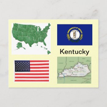
State of Kentucky Map and Flag Postcard

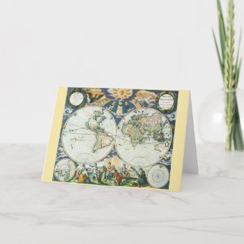
Vintage illustration antique world map featuring birds flying towards a shining sun casting rays over the hemispheres and continents. Below the chart is a set of allegorical figures representing the four seasons, summer, autumn, spring and winter. Orbis terrarum nova et accuratissima tabula. Artist: Pieter Goos, 1666.
Continue reading

A 12-month calendar featuring a selection of satirical European maps from Yanko Tsvetkov's Mapping Stereotypes project, poking fun at prejudices and national stereotypes on the continent. Contains maps according to the USA, Great Britain, Germany, France, Italy, Russia, Switzerland, Turkey, the Vatican, Poland, Bulgaria and Greece.
Continue reading

Fine 18th century original vintage antique illustrated world map. Detailed early historical cartographic atlas scan is a retro reminder of early history. This scanned atlas museum archive illustration is a decorative ancient specimen from the vault, an old geographical record of times past.

1847 Molini Pocket Map of Florence Italy

Round button with the flag of flag of the Czech Republic.

Round keychain with the flag of Brazil.

Flag Posters and Flag Gear: Flag T-shirts, Flag Tees, Flag Shirts, Flag Hoodies, Flag Bumperstickers, Flag Buttons, Flag mugs, Flag magnets, Flag keychains, Flag Bags, Flag gifts from Shirtuosity.com

Vintage illustration antique world map featuring the continent of Africa and the island of Madagascar, c. 1635. By cartographer Willem Jansz Blaeu (1571-1638). Willem Janszoon Blaeu was a Dutch cartographer, atlas maker and publisher. The Atlantic and Indian Oceans have ships sailing the seas to travel and navigate the globe. Surrounding this international African chart are people dressed in native costumes and along the top edge are smaller city maps.
