
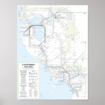
A transit map for all of California – from San Diego to LA to the Bay Area, Sacramento, and beyond! Whereas many of us Californians have dreamed of road trips over a highway map, the California Rail Map shows 500+ destinations reachable on the train or connecting bus or ferry. This map is designed to look good at sizes of 16″x21″ or larger. The background is actually white. You can preview the map in detail at www.californiarailmap.comThe map includes rail lines of the following agencies: Amtrak, BART, VTA, Caltrain, Altamont Commuter Express, Sacramento Regional Transit, San Diego North County Transit District (NCTD), San Diego Trolley, LA Metro, and Metrolink. Key bus and ferry connections between services are also shown on the map. Version 1.01
Continue reading

